Volcanoes in Iceland
Updated · BootsnAll
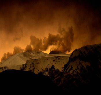 Iceland sits on the Mid-Atlantic Ridge, where the North American and Eurasian plates pull apart, and on top of a mantle hotspot. The result is a country with 33 active volcanic systems, according to the official Catalogue of Icelandic Volcanoes. When I first wrote this page in 2010, everyone was learning to (not) pronounce Eyjafjallajökull. Since then Iceland has had a string of eruptions, and the one people ask about now is on the Reykjanes peninsula, a short drive from Keflavík airport.
Updated September 2026.
What's happening right now
As of mid-September 2026 there is no eruption in Iceland. That could change quickly. The Icelandic Met Office reported on 15 September 2026 that the ground at Svartsengi is still rising, by about 5 cm over the previous three months, and its August update put the magma added since the last eruption began in July 2025 at about 29 million cubic metres. Its view is that the most likely next step is another magma intrusion into the Sundhnúkur crater row, which could end in an eruption. Past eruptions there gave between about 20 minutes and four hours of warning. Iceland's Civil Protection has kept the area at its lowest alert level, the uncertainty phase, since 7 August 2025.
Before you travel, check two sites:
- Icelandic Met Office's Reykjanes update for the current hazard assessment.
- SafeTravel's Reykjanes eruption page for closures, hiking routes and what's open.
Reykjavík itself hasn't been threatened, and the government says the Reykjanes eruptions haven't affected flights to and from Iceland. The effects land on Grindavík, the Blue Lagoon and the roads around them. If those are on your plan, read the Blue Lagoon page and keep your booking flexible.
The Reykjanes eruptions, 2021 to 2025
The Reykjanes peninsula had been quiet for about 800 years until March 2021. Since then it has barely stopped.
Fagradalsfjall, 2021-2023
Three eruptions in uninhabited valleys drew huge crowds, because you could hike to them from the road. According to Wikipedia's summary, they ran:
- 19 March to 18 September 2021, in Geldingadalir
- 3 to 21 August 2022, in Meradalir
- 10 July to 5 August 2023, at Litli-Hrútur
The lava fields are still there and still worth the walk. SafeTravel lists marked routes, from a 4 km path to a viewpoint up to an 18-20 km round trip to the 2023 site. Stay on the paths and don't walk on the lava. The crust can be thin with hot rock underneath, years after it looks dead.
Sundhnúkur and Grindavík, 2023-2025
In November 2023 a large magma intrusion ran under the fishing town of Grindavík, and the town was evacuated. Nine eruptions followed along the Sundhnúkur crater row, between December 2023 and August 2025:
- 18-21 December 2023
- 14-16 January 2024 (lava reached Grindavík and destroyed three houses)
- 8-10 February 2024
- 16 March to 9 May 2024
- 29 May to 22 June 2024
- 22 August to 6 September 2024
- 20 November 2024, for about 18 days (lava covered the Blue Lagoon car park and its access road)
- 1 April 2025, over in about seven hours
- 16 July to 5 August 2025
Grindavík is open to visitors again, but SafeTravel still calls the area hazardous. Cracks open in the ground, so stay on paths, and know the evacuation route out.
The big names
Eyjafjallajökull (2010)
The eruption started as a tourist-friendly fissure on Fimmvörðuháls in March 2010, then moved under the glacier in April and threw up the ash cloud that closed European airspace. More than 100,000 flights were cancelled. I wrote about it as it happened in Iceland's Eyjafjallajökull eruption, and if you need cheering up there's a page of volcano jokes from that spring. You can hike across the new craters, Magni and Móði, on the Fimmvörðuháls trail between Skógar and Þórsmörk, about 20 km with 1,000 m of climbing and 8 to 12 hours of walking. It's a summer hike.
Grímsvötn (2011)
Iceland's most active volcanic system sits under the Vatnajökull ice cap. Its eruption of 21 to 28 May 2011 was bigger than Eyjafjallajökull's for its first few days, with an ash column around 20 km high, yet only about 900 of 90,000 planned European flights were cancelled over 23-25 May. It belongs to the same volcanic system as Laki (below).
Bárðarbunga and Holuhraun (2014-2015)
From 29 August 2014 to 28 February 2015, lava poured out at Holuhraun, north of Vatnajökull. It was the largest lava eruption in Iceland since Laki, covering about 85 square kilometres. There was almost no ash, so flights carried on, but sulphur dioxide drifted over much of the country. The lava field is in the highlands, reachable only in summer on F-roads.
Hekla
Hekla used to run like a clock. It erupted in 1970, 1980-81, 1991 and 2000, a roughly ten-year rhythm that has now stretched past 26 years. The last eruption began on 26 February 2000 and lasted until 8 March. People hike it in summer (about 3-4 hours up), but check the Met Office before you go.
Katla
Katla sits under Mýrdalsjökull, just east of Eyjafjallajökull, and is the one geologists watch hardest. Its last eruption to break through the ice was in 1918, and over the last 1,100 years it has averaged about one eruption every 50 years, so it's overdue. The 1755 eruption sent out a flood estimated at the combined flow of the Amazon, Mississippi, Nile and Yangtze. Katla also produces smaller glacial floods: one came down the Múlakvísl river starting 18 August 2026 and was subsiding by the start of September. If you're driving the south coast near Vík, keep an eye on road conditions.
Laki (1783-1784)
The worst of them all. For eight months, from June 1783 to February 1784, the Laki fissure poured out lava and gas. Fluorine poisoning killed much of the country's livestock, and Iceland lost almost 20% of its population in the famine and disease that followed. The haze spread over Europe, and the next winter the Mississippi froze at New Orleans.
Eldfell (1973)
On 23 January 1973 a fissure opened on the edge of the town on Heimaey in the Westman Islands, and more than 5,000 people fled their homes that night. Eldheimar, a museum on Heimaey, tells the story. It's open daily 11:00-17:00 and adult entry is 3,550 ISK (as of 2026).
Seeing volcanoes without an eruption
- LAVA Centre in Hvolsvöllur, on the Ring Road in the south, is an interactive exhibition on Icelandic volcanoes. Adult tickets are 5,200 ISK for the exhibition and film (as of 2026).
- Þríhnúkagígur, about 25 minutes from Reykjavík, is a dormant volcano whose empty magma chamber you can be lowered into with Inside the Volcano.
- Lava caves like Raufarhólshellir and Leiðarendi are near the capital; see outdoor activities.
- The Fagradalsfjall lava fields are the easiest fresh lava to walk to from Reykjavík. More ideas are on the natural wonders and day tours pages.
FAQ
Is it safe to visit Iceland during an eruption?
Usually, yes. Recent eruptions have been fissure eruptions with little ash, and flights kept running. The danger is local: closed roads, gas, and people walking onto lava. Follow SafeTravel and do what the police and rescue teams tell you. I wrote about the same question in 2010 in should you visit during the eruption.
Will an eruption cancel my flight?
Only if it throws ash into the flight path, which the Reykjanes eruptions haven't done. Keflavík is close to the eruption zone, so the bigger risk is a road closure on the way to the airport. Check umferdin.is before you leave.
Can I see flowing lava?
Only when something is erupting, and only from the viewpoints the authorities open. Tour operators and helicopter companies add trips quickly when an eruption starts.
How many people live near the volcanoes?
About 64% of Iceland's 396,500 people live in the capital region, which none of the recent eruptions have reached. The people of Grindavík are the ones who lost their homes.
Photos by Sverrir Thor